See Galveston Fishing Bible in action

▶ Watch the video

FOR GALVESTON BAY ANGLERS & WEEKEND BOATERS

Your Galveston Bay
fishing plan,
in one place.

Know what, where and when they bite. Bring Galveston fishing spots, seasonal guidance and the day’s conditions together before you leave the dock.

One free morning? Make a game plan before you cast instead of wasting it hunting through apps or getting skunked without knowing where to start.

One-time payment. No automatic renewal.
For Galveston Bay anglers, weekend boaters and first-timers. A local guide—not a nationwide fishing app.

Actual app screenshot of Today’s Fishing Outlook, showing sunrise, sunset and the captured conditions index
TODAY’S FISHING OUTLOOK · ACTUAL APP SCREENCaptured October 25, 2026 · readings shown are not live.
476 mapped locations14 founding anglers on boardBay + nearby offshore spots$5 for 12 monthsNo automatic renewal
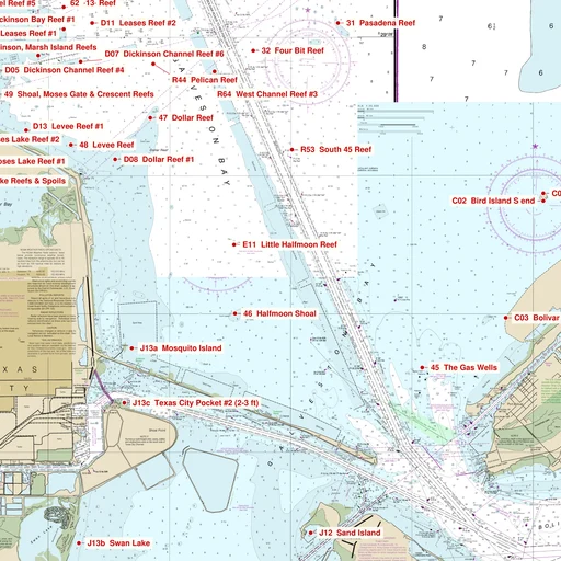
Actual NOAA-based app chart excerpt showing Dollar Reef, Levee Reef, Halfmoon Shoal and the Houston Ship Channel
ACTUAL APP CHART EXCERPTFind a place to make your next memory.

DO NOT USE FOR NAVIGATION

START WITH THE WATER YOU KNOW

Your familiar spots.
A few new possibilities.

Explore named reefs, shoals, bay fishing holes and nearby offshore locations. Choose your month and target fish, then see the locations with matching guidance.

New to the bay or taking the family? Start with ten named fishing spots, then check the conditions and ramp information. Head out feeling prepared.

From Clear Lake and Trinity Bay to East Bay, West Bay and the Christmas Bay area, get a closer look at the places around your next trip.

  • Detailed NOAA-based charts with named fishing locations
  • Seasonal notes and bait suggestions for redfish, trout and flounder
  • GPS position, distance and bearing to a selected spot
  • Marinas, ramps and listed amenities nearby

GPS guidance is a straight line to a waypoint, not a safe boating route. Use current marine navigation charts.

LOOK AT THE WHOLE PICTURE

Less tab-hopping.
More time thinking about fishing.

Pull up the tools you need in one place. Check the latest available readings and forecasts, then make your own call for the day.

01 / CONDITIONS

What’s the bay doing?

Weather, wind, tides, sunrise and sunset, wave height and period, radar, pressure and modeled salinity. A daily fishing outlook brings several factors together.

The outlook is an experimental planning index. Readings and models may represent a nearby station rather than your exact spot.

02 / TIMING

Pick your window.

Explore moon phases and a monthly solunar calendar, with plain-language explanations of major and minor fishing periods.

Solunar windows are a planning reference; they do not guarantee a bite.

03 / LOCAL KNOWLEDGE

Know what you’re targeting.

Build a game plan for familiar honey holes or new spots with dated fishing reports, bait guidance, fish identification photos and regulation references. See the source and location coverage behind report observations.

SEE THE REAL APP

A little more prepared.
Before the first cast.

Here’s how the tools fit into a day on Galveston Bay.

Actual app screenshots captured October 25, 2026. The readings, rules and listings pictured are examples, not live information.

TODAY ON THE BAY

Is it a good day
to go fishing?

Take a look at Today’s Fishing Outlook before you load the boat. Sunrise, sunset and a conditions index give you a quick starting point for your day.

Refresh the outlook as your plans change to see how the latest available factors line up. Open the details to see what went into the rating.

A planning aid, not a promise of a bite. Readings may come from a nearby station.

Actual app screen of Today’s Fishing Outlook, sunrise, sunset and conditions index
Today’s Fishing Outlook · captured app screen

KNOW THE WEATHER BEFORE YOU GO

Check the bay.
Then make your call.

Wind picking up? Wondering about the waves? Bring the weather tools together before you head out, and check them again while you’re on the water.

Open weather, waves, radar, NOAA radio, moon times, salinity and barometric pressure from one place. Choose a fishing spot for its local reference information.

Observations and forecasts have their own update times and location coverage.

Actual app screen of the weather and conditions buttons
Weather & conditions · captured app screen

WTH DID I CATCH?!

Put a name
to that fish.

A fish on the line and a question in your head? Browse color photos and identifying features to help work out what you caught.

Keep species descriptions and regulation references close, including size and bag-limit information, before deciding what goes in the cooler.

Check current official rules and confirm the species before keeping a fish.

Actual app screen showing redfish identification and regulation references
Fish identification · captured app screen

BAIT. FUEL. ICE. A PLACE TO LAUNCH.

Find the stop
your trip needs.

Need live bait, a fuel stop or a nearby ramp? Look through marina and launch listings to see amenities, contact details and where a facility sits on the chart.

The Blue Marlin example shows listed amenities, contact details and source information together, so you know what to check before stopping in.

Call ahead to confirm access, hours and supplies. A chart position is not a verified entrance or a safe route.

Actual app listing for Blue Marlin Fuel Dock and its amenities
Blue Marlin Fuel Dock

Plan your next day on the bay ↗

THE BEST PART COMES AFTER THE CAST

Catch it.
Remember it.
Share the day.

Put your catch in the gallery.

Add your photo, name and fishing location. Browse everyone’s catches or filter the gallery by spot.

Save the bite that was worth remembering.

Log your bait, notes and available conditions at a chart location or a private GPS spot. Opt into emails when selected conditions line up again.

Keep practical help close.

Find NOAA weather radio, marina information and emergency or towing contacts while planning your time on the bay.

WHY I BUILT IT

“I wanted everything I kept looking for before a fishing trip in one place.”

I’m Mike, and I built Galveston Fishing Bible out of my own love of fishing these waters. Planning a day on the bay meant piecing together charts, fishing reports, weather and ideas about what to catch.

I set out to make that easier: a local fishing companion that brings useful information together, helps you explore the bay and gives anglers a place to share their catches and knowledge.

Mike Slevens Founder, Galveston Fishing Bible

Mike Slevens, founder of Galveston Fishing Bible, holding a fishing rod beside the bay
Mike Slevens · Founder, Galveston Fishing Bible

FROM FELLOW ANGLERS

What people are saying.

Swipe or scroll to read all six reviews.

I have looked everywhere for an app like this! So many people come here to fish on vacation and don’t know where to go! This is a game changer!
Sharon Green
Seriously? Only $5.00 for the year? Fishbrain charges more than that a month for less! This is great!
Anthony Marker
Dude this site rocks! I will be using this for my charters from now on! Thanks!
Gus Alvarez
This site has everything you need and more to find the fish! Great concept and great APP!
Scott Venhaus
I can't tell you how many times I have gone out fishing with no idea where to go, this takes all the guess work out of it! Amazing!
Jeff Krit
I would pay this per month for what you get! Five bucks is a deal!
Jason Marcal

Personal experiences shared by anglers. Individual results vary.

KEEP IT SIMPLE. GO FISHING.

A year of possibilities.
One small payment.

Explore the app’s fishing spots, planning tools and catch-sharing features with 12 months of access.

12 MONTHS OF ACCESS

476 mapped fishing locations

14 founding anglers on board

$5 USD total

One-time payment.
No automatic renewal.

Get started

Sign up with your email. No ChatGPT account required. This offer covers 12 months; later renewal pricing has not been announced.

COMPARE YOUR OPTIONS

A local guide alongside the big fishing apps.

See how Galveston Fishing Bible compares with Fishbrain, Fishbox and FishAngler on price, fishing information and Galveston Bay knowledge.

US prices and product information checked October 28, 2026. Prices, plans and features can change by offer, platform and region.
CompareGalveston Fishing BibleFishbrainFishboxFishAngler
Price$5 for 12 months
One-time introductory price for the first year; no automatic renewal.
Free app
$12.99 monthly or $79.99 annual Power Fishing package on the US App Store.
Free download
US App Store lists Premium prices from $7.99 to $35.99; plan lengths and offers vary.
Free app
VIP is $6.99 monthly or $49.99 yearly on the US App Store.
Information content476 mapped locations, NOAA-based charts, seasonal notes, fish identification and regulation references, dated fishing reports, weather, tides, waves and moon tools.Community catch reports, maps and depth layers, bait recommendations, BiteTime forecasts, weather, tides, catch log, fish identification and regulations.Interactive maps, spot finder, forecasts, weather, tides, solunar data, bait and lure guidance, knot tutorials, catch tools and AI assistance.Fishing forecasts, local reports, bait and lure recommendations, 10-day weather, tacklebox and catch log; VIP adds exact catch positions and premium map layers.
Local knowledgeFocused on Galveston Bay. Named spots across Galveston Bay, Clear Lake, Trinity Bay, East Bay, West Bay and nearby waters, with dated reports and source/location notes.Local information comes from its broad angler community and catch reports across many regions.Location-based spot maps and forecasts support a broad range of freshwater and saltwater trips.Local reports and catches come from a broad angler community; maps and forecasts cover locations across regions.

Prices are not perfectly comparable because subscription lengths, trials and in-app offers differ. See the full app comparison and source links ↗

BEFORE YOU HEAD OUT

A few good questions.

Do I need to download an app?

No. Open gfishbible.com in your phone’s browser. You can also add it to your home screen for easy access. You’ll need an internet connection for current conditions and online features.

What area does it cover?

The chart covers the Galveston Bay area, including Clear Lake, Trinity Bay, East Bay, West Bay, the Christmas Bay area and nearby offshore waters within the app’s approximately 30-mile offshore window. Check the chart for the exact coverage of your planned trip.

Does it guarantee I’ll catch fish?

No. Seasonal guidance, reports and condition tools help you plan, but weather, bait movement and fish behavior change. Historical reports retain their dates; a lack of reports does not mean fish are absent.

Can I use the chart to navigate my boat?

No. The app’s chart and straight-line GPS guidance are fishing references, not marine navigation tools. The line does not avoid reefs, shoals, land, traffic or other hazards.

Will you charge me again automatically?

No. The $5 purchase provides 12 months of access with no automatic renewal.

Are my private GPS fishing spots visible to everyone?

Private GPS locations saved with Save This Bite stay with your account. Catch Gallery photos and the fishing locations you choose to share there are visible to other app members.

YOUR NEXT DAY ON THE BAY STARTS HERE

Bring a little local knowledge aboard.

Start fishing